Friday 30 August 2013

Cirrus Clouds

Cirrus clouds are white or light grey thin, wispy tails of cloud. They occur when water vapour undergoes deposition above 5,000 metres in temperate regions or 6,100m in tropical regions. They often appear before a frontal system or tropical cyclone. These types of cloud can also produce several optical effects.


Cirrus Clouds


Glories

Glories are concentric, faintly coloured rings that appear around the shadow of the observer. For this to happen, the ice crystals in the clouds need to be aspherical.

Circumhorizontal Arc

These are similar and just as common as a rainbow, but in an upside down curve. This is when the ice crystals are horizontal, flat and hexagonal. Light from the sun passes through the circumhorizontal arc causing the sunlight to refract and invert, creating a colourful, upside down arc. The sun must be at a lower altitude than 32 degrees and an angle of 20 degrees above the horizon causes the brightest of arcs. They go from blue on the inside via green, to yellow and then to red on the outside. Circumhorizontal arcs have purer colours which are more clearly separated then a rainbow as the sunlight that is refracted is almost parallel.


Circumhorizontal Arcs

Thursday 29 August 2013

Acid Rain

Acid rain describes any form of precipitation with high levels of nitric and sulfuric acids. It can also occur in the form of snow, fog, and tiny bits of dry material that settle to Earth which is known as acid deposition.

Acid rain can occur due a natural reasons such as rotting vegetation and volcanoes which release chemicals, but the main cause is human activity. Burning fossil fuels, coal-burning power plants, factories and cars all release sulfur dioxide (SO2) and nitrogen oxide (NO2) into the atmosphere. These gases react with water, oxygen and other gases to form sulfuric acid, ammonium nitrate and nitric acid. The wind disperses the acids over hundreds of miles across the globe before they fall to Earth in some form of precipitation.

The deposition can occur in either one of two ways; wet or dry deposition.

- Wet deposition is where precipitation removes acid from the atmosphere and is deposited on Earth.
- Dry deposition is when polluting particles and gases stick to the ground via dust and smoke in the absence of of precipitation. Precipitation will then eventually wash pollution into streams, lakes and rivers.

Acid deposition increased dramatically after the industrial revolution and was first discovered in 1852 by a Scottish chemist, Robert Angus Smith. However public awareness to acid deposition did not grow until the 1960's and 70's.


Effect of Acid Rain

Acid rain has many ecological effects - aquatic environments such as lakes,streams and wetlands being the most clearly impacted areas. Acidic precipitation falls directly into them along with water run off and ground water all flowing into them. The water becomes acidic, at first it is a diluted form of acidity but eventually it all builds up. This causes aluminium and magnesium to be released from the soil, decreasing the waters pH further, while also being toxic to aquatic animals such as crayfish, clams and fish. If the pH of a lake drops below 4.8, it's plants animals are at risk of death. It is estimated that 50,000 lakes in the USA and Canada have pH levels below normal, and several hundred of these have a pH level too low to support aquatic life.

Furthermore, the effect on aquatic life can also lead to diminishing numbers of other animals. This is due to the food chain being altered, so predators such as birds have less food due to fish dying in lakes and streams.

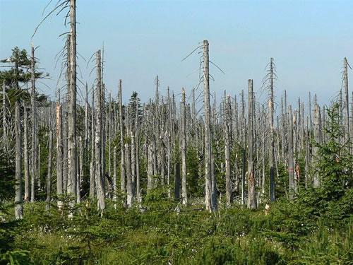
Forests can also be extremely damaged by acid deposition. Especially forests at higher elevations where precipitation is more frequent and suffer problems induces by the acidic cloud cover as the moisture in the clouds blanket them. The acid in water droplets can damage leaves and bark on the trees and cause stunted growth. This means they are more vulnerable to disease, cold temperatures, extreme weather and insects, while also having the possible effect of inhibiting the ability to reproduce. In addition, the release of aluminium in the soil makes it hard for trees to take up water. The acid kills micro-organisms in the soil, disrupting nutrients and can cause calcium deficiency.  Some soils can neutralise acid, the lower the 'buffering capacity', the larger the effect of acid rain on the soil and forests.


A forest damaged by acid rain

The most advance cases of forest damage is occurring in Eastern Europe. It is estimated that half of the forests on Germany and Poland are damaged by acid deposition, while it is roughly 30% of forests effected in Switzerland.

Architecture and art can also be damaged. Acid has the ability to corroded materials, especially limestone. The acid reacts with materials in the stone which disintegrate and wash away. Modern buildings as well as pipes above and below ground, cars and railway tracks can all be damaged.


Statues eroded by acid rain


Preventing Acid Rain

Due to these problems and the adverse effects on human health, methods are being used to reduce damage caused by acid rain. One is by cleaning smoke stacks by using scrubbers which trap pollutants before they are released into the atmosphere. Other ways are by having catalytic converters in cars to reduce emissions, promoting alternative energy sources and conservation of energy. Funding has also been given to restore ecosystems damaged by acid rain all over the world.  

Wednesday 28 August 2013

Fossil Forests in Antarctica

Antarctica - the frozen, windswept continent with ice over 3km thick. Yet the ice caps have only appeared relatively recently in geological history. It is hard to think that once, Antarctica was a lush green land with rainforests in the south.


Evidence for this was first discovered over 100 years ago by explorer Robert Falcon Scott in 1912. He stumbled over fossils on the Beardmore Glacier full of leaves and twigs. Some fossils that were found proved to be remains of Beech, Pine and Fern trees, dated at 3-5 million years old, very similar to those found in New Zealand and Tasmania today.


Fossil leaf of Glossopteris Indica collected by Captain Scott

Since then, more plant fossils have been found preserved within sandstone and mudstone of the Antarctic Peninsula, some dating back as far as 100-250 million years ago. This was when the world was experiencing extreme Greenhouse effects, with temperatures much warmer than today.

Clusters of petrified tree stumps were found upright in their original living positions. This has allowed us estimate that the trees grew up to about 25 metres tall based on the diameter of the trunk. Furthermore, they grew very densely, roughly 1000 trees per acre.

The plants and trees would have needed very special adaptations to survive in Antarctica. This is due to the fact that in the summer the days have 24 hours of sunlight, but in the winter there is only darkness. Tree rings show that they only grew in the summer, much like trees today, however trees back then would have stopped growth due to light levels whereas today it is due to temperature. 

The question that has been asked many a time now is 'With the world experiencing another event of global warming, will we see trees back on Antarctica?' Although it is entirely possible, 
 plant species would have to migrate the Southern Ocean from Australia or South America for this to happen.


Antarctica today

Tuesday 27 August 2013

Electric Blue Sea - a natural phenomenon

Have you ever seen a field full of flickering fireflies? What about a video of glowing jellyfish in the deep sea? These animals aren't the only glow-in-the dark creatures on Earth. The most common ones are much smaller, phytoplankton.


Electric blue sea in the Maldives


Bio-luminescent plankton don't glow in the dark all the time. It takes energy to make the chemicals that mix together and produce a glow. One example of bio-luminescent algae is a dinoflagellate called Noctiluca, or Sea Sparkle. They are so small that thousands can fit into a single drop of water.   

In some places such as the Caribbean, Sea Sparkle are so abundant that the water sparkles neon blue at night when you run your hand through it.

The dinoflagellate bloom every few years, forming what is known as a red tide. While the algae gives the water a soupy red coluor during the day, night time is when the show begins. Every time the algae is jostled — either by the movement of the tides or the slice of a kayak moving through the water — it emits a bright blue bio-luminescent glow.


Waves in San Diego

Monday 26 August 2013

Sand Dune Succession

A sand dune is formed by the accumulation of sand grains shaped into moulds and ridges by the wind. The succession of a sand dune is called a psammosere. This is the long term change in a plant community as it develops from a bare inorganic surface to a climax community (a group of species best able to exploit prevailing environmental conditions).

Each stage of a succession is called a sere, the first being the Pioneer stage. This occurs at he strand line (see diagram below). Extreme high tides or storm tides may leave a zone of several metres landward of the normal high water mark, causing the sand to be dry,salty, unstable with little nutrients and alkaline conditions. This is therefore not suitable for plant growth. Seeds are blown in by the wind or washed in by the sea and pioneer plants - highly specialised, tolerant plants - may colonise such as Sea Rocket. These may form miniature dunes as the sand gradually accumulates around the plants.

The next sere is the building stage which occurs at a few sections of a sand dune. The first is at embryo dunes. Sand accumulation which persists above the high tide line maybe suitable for colonisation by the first perennial plants in dune succession which are specialised grasses, for example Sand Couch and Lyme Grass. Both of these are able to grow upwards through accumulating wind-blown sand. As a result low, hummocky dunes are formed however the substrate is still inhospitable for plant growth.

Marram GrassThe upward growth of embryo dunes allows the surface of fore dunes or mobile dunes to be raised so that it is out of reach all but the highest storm tides. Incursion of rainwater results in less salty substrate so Marram Grass is able to colonise and become the dominant species. It is able to grow upwards through accumulating sand and rates of up to 1 metre per year. Dead leaves of the Marram Grass adds organic material to the soil, releasing plant nutrients which leads to increasing biodiversity and less bare ground.  

                  
If conditions remain stable, mosses will cover bare sand patches in yellow or white (semi-fixed) dunes between Marram grass and plants. Mosses such as Restharrow ans Sand Sedge will become common and species diversity should continue to increase.

When vegetation has developed so that is forms a cover on the substrate, the dunes are 'fixed'. There is still a low nutrient status and risk of plant desiccation. Dunes maybe influenced by grazing and trampling however an organic layer starts to form on the surface. It can be a very species rich environment with plants such as Bedstraw, Wild Thyme and Harebell. These areas are of considerable conservation importance. 

Depending on height of the water table, areas between sandy hills may be damp or even contain standing water. These are called dune slacks. Receiving nutrients leached from the surrounding dunes, they may be occupied by lime-loving species and can be rich with local or national rarities. Orchid species may sometimes be prominent species of the dune-slack community.

In absence of grazing animals, succession proceeds and tall woody plants such as Birch and Hawthorn form natural invaders. These areas are called dune scrubs. They tend to be species-poor, so in many areas management has focused on the clearing of scrubs and introduction of grazing animals to maintain the open dunes.

If grazing prevents the development of scrub or woodland, then fixed grassland known as dune heath, will eventually develop. This is plagio-climax because it results from human activities. The vegetation id dominated by plants that are adapted to grasslands and heathlands, tolerating dry, acid and nutrient poor substrate. A common invader is heather.

The final sere is the climax stage. Deciduous woodland is the natural climax vegetation of a dune system. Oak or Scots Pine are able to colonise the scrub. Plants from earlier stages die out due to competition for water, light and nutrients. Unfortunately the landward margins are often managed as golf courses, agricultural land or replaced by plantations, meaning that community climax is not always reached.


external image psammo.gif

Saturday 24 August 2013

Glaciers

A glacier is essentially a huge mass of ice resting on land or floating in the sea next to land. Moving extremely slowly, a glacier acts similarly to an immense river of ice, often merging with other glaciers in a stream-like manner.

Regions with continuous snowfall and constant freezing temperatures foster the development of these frozen rivers. It is so cold in these regions that when a snowflake hits the ground it does not melt, but instead combines with other snowflakes to form larger grains of ice. As more and more snow accumulates, mounting weight and pressure squeeze these grains of ice together to form a glacier.

A glacier cannot form unless is it above the snowline, the lowest elevation at which snow can survive year round. Most glaciers form in high mountain regions such as the Himalayas of Southern Asia or the Alps of Western Europe where regular snow and extremely cold temperatures are present. Glaciers are also found in Antarctica, Greenland, Iceland and Canada.

Glaciers may be retreating worldwide due to global warming, but they still cover about 10% of earth’s land and hold about 77% of earth's freshwater.

Types of Glaciers

Alpine Glaciers or otherwise known as mountain/cirque glaciers form on the side and crests of mountains with subtypes such as;
- Valley glaciers are where the glacier takes up the space of an eroded stream or a valley.
- Tidewater glaciers are where glaciers meet the sea. Icebergs are formed when parts of the glacier break off.

Continental Glaciers are bigger then alpine types. They are an expansive, continuous mass of ice.
- Ice sheets are the largest type of glacier. They can extend over 50,000 square kilometres and are only found in Greenland or Antarctica.
- Ice caps are smaller and are a rough circular shape that blanket the landscape.
- Ice fields are the smallest continental glaciers. Tend to be elongated and do not cover the land.

The speed of glaciers can be from rest to over a km per year, but on average move a couple of hundred feet a year.

Glaciers have formed many landscapes and formations we see today by the process of abrasion. Glaciers can pick up rocks as they move and grind, squeeze and erode the land they are moving over. Creating new formations. Many common types of formations are U-shaped valleys, long, oval hills called drumlins and hanging waterfalls. Moraines are also common. These are formed by the deposition of materials from a glacier and appear as linear mounds of mixed rock.


Perito Moreno Glacier, Argentina


 Moraine above Lake Louise, Canada


Friday 23 August 2013

Machu Picchu

Not only is Machu Picchu one of the most important archaeological sites in South America, filled with historical mysteries, but it also boasts stunning views from the Peruvian Andes mountain range, 2,450 meters above sea level. Machu Picchu, in one of the Peruvian dialects, stands for Old Mountain and that is the name of the peak where the city is located.

Similar to most tropical locations, the season in Machu Picchu is divided into a rainy season which starts at October and ends on April the next year, and a dry season for the remainder of the year.

At the valley below the Incan city snakes the Urubamba River whose meandering path through the centuries carved cliffs some as high as 450 meters. The menacing cliffs plus the extreme elevation of the city made it a secret to the Spanish conquistadores who were searching in vain for the gold treasures of the fabled city of El Dorado. It was only through an Inca rope bridge at the Pongo de Mainique where a secret entrance to Machu Picchu for the exclusive use of the Inca army was found. Another bridge was found in a narrow gap between the river gorge.

It was formed by a felled tree trunk but the bridge could be easily set aside to discourage invaders. The tree trunk bridge was the only other access across the cliff whose sides drop almost 570 meters down into the river below.

The ancient city is situated in a saddle between two mountains important to Inca culture. While the other mountain was already named Machu Picchu, Huayna Picchu, which stands for Young mountain, is the other peak that nestles the ancient monument. Machu Picchu was by all means a self contained city.

It had a reliable water supply thanks to the ice fed rivers that flow along the Andes and enough level land for agriculture. Terraced hillsides added to the total amount of arable land and at same time made the slopes harder to ascend if ever invaders chose that path. Machu Picchu was a veritable fortress with easily defensible entrances. One entrance was the Sun Gate which traverses the mountains and leads to Cusco, the other was the Inca bridge.


Machu Picchu


View from the Incan city

Monday 19 August 2013

Earthquakes

There are 3 main types of plate boundaries, all of which can cause earthquakes. These are destructive, constructive and conservative margins.

Destructive Boundary

- Subduction zones are one type of destructive boundary. This is where an oceanic and continental plate move together. The oceanic crust is more dense and therefore is submerged below the continental crust. Earthquakes occur where the plates rub together, bend and fracture. The oceanic crust melts, forming magma, which rises and forms a volcano. This occurs in the Andes.


- Collision zones are the other type of destructive boundary. This involves two continental plates moving towards each other. Earthquakes occur as rock folds and fractures. An example of this is in the Himalayas.


Constructive Boundary

This is where two oceanic plates are moving away from each other. The mantle near the gap that is made melts due to decreasing pressure. The mantle comes out as pillow lava when underwater, with volcanoes all the way down the ridge. There are minor earthquakes due to lava solidifying and collapsing. An example is the Mid Atlantic Ridge.


Conservative Boundary

Two plates rub against each others side as they move in opposite directions. The earthquakes caused by this can be extremely dangerous as often, the tension between the two plates builds up, before suddenly being released, causing dramatic shocks through the ground. The San Andreas Fault is an example of this.